Home > Arts > Landscape paintings > Cityscape art > Nature-inspired artwork
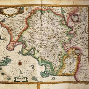
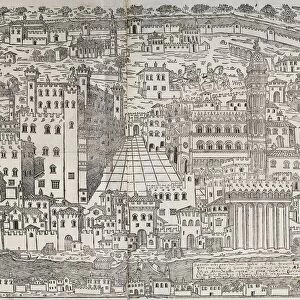
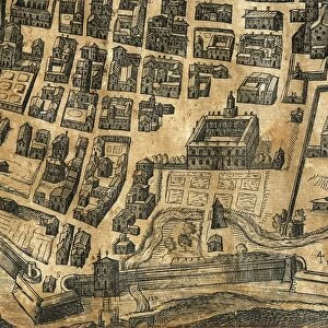
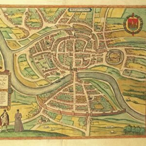
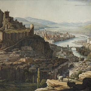
Map of Gallipoli, from Civitates Orbis Terrarum by Georg Braun, 1541-1622 and Franz Hogenberg, 1540-1590, engraving

![]()
Wall Art and Photo Gifts from Universal Images Group (UIG)
Map of Gallipoli, from Civitates Orbis Terrarum by Georg Braun, 1541-1622 and Franz Hogenberg, 1540-1590, engraving
Cartography, Italy, 16th century. The City of Gallipoli. From Civitates Orbis Terrarum by Georg Braun (1541-1622) and Franz Hogenberg (1540-1590), Cologne. Engraving
Universal Images Group (UIG) manages distribution for many leading specialist agencies worldwide
Media ID 9571089
© DEA / A. DAGLI ORTI
16th Century Aerial View Apulia City Cityscape Coastline Coat Of Arms Connection Country Road Direction Fortified Wall Franz Hogenberg Georg Braun Guidance Human Settlement Island Journey Nautical Vessel Navigational Equipment Old Town Peninsula Road Rooster Sailing Boat Sailing Ship Ship Surrounding Wall Text Transportation Wall Animal Representation Gallipoli Non Urban Scene
FEATURES IN THESE COLLECTIONS
> Architecture
> Country
> Italy
> Related Images
> Arts
> Artists
> H
> Franz Hogenberg
> Arts
> Landscape paintings
> Cityscape art
> Nature-inspired artwork
> Europe
> Italy
> Aerial Views
> Europe
> Italy
> Sculptures
> Universal Images Group (UIG)
> Art
> Painting, Sculpture & Prints
> Cartography
EDITORS COMMENTS
This print showcases a remarkable piece of cartographic history - the Map of Gallipoli, meticulously crafted by Georg Braun and Franz Hogenberg in the 16th century. The engraving, part of their renowned work "Civitates Orbis Terrarum" offers a fascinating glimpse into the city's past. The image captures an aerial view of Gallipoli, an enchanting Italian island nestled on the Apulia peninsula. Its old town is encircled by a fortified wall, which stands as a testament to its rich historical significance. As we explore this ancient cityscape, we are drawn to the intricate details that adorn it - from architectural marvels to coat of arms proudly displayed. Intriguingly, amidst this topographical masterpiece lies evidence of bustling activity. Sailing ships gracefully traverse the surrounding waters while smaller vessels dotting the coastline hint at vibrant maritime trade routes. A rooster perched atop one building exterior symbolizes connection and guidance for seafarers embarking on their journeys. The map itself serves as both navigational equipment and artistry; carefully engraved lines depict roads leading in various directions across land and sea alike. Textual annotations provide further insights into this region's history and culture. As we immerse ourselves in this visual treasure trove, our imagination takes flight with thoughts of explorations past - reminding us that even centuries later, maps continue to hold immense power in connecting us to our collective human heritage.
MADE IN THE USA
Safe Shipping with 30 Day Money Back Guarantee
FREE PERSONALISATION*
We are proud to offer a range of customisation features including Personalised Captions, Color Filters and Picture Zoom Tools
SECURE PAYMENTS
We happily accept a wide range of payment options so you can pay for the things you need in the way that is most convenient for you
* Options may vary by product and licensing agreement. Zoomed Pictures can be adjusted in the Cart.