Home > Europe > United Kingdom > England > London > Art > Paintings
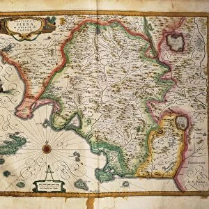
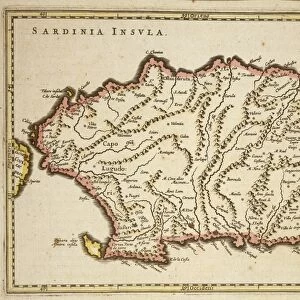
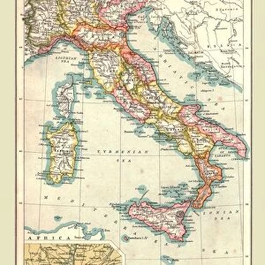
Map of the States under the King of Sardinia, London, engraving on copper, 1816

![]()
Wall Art and Photo Gifts from Universal Images Group (UIG)
Map of the States under the King of Sardinia, London, engraving on copper, 1816
Cartography, Italy, 19th century. Map of the States under the King of Sardinia, London 1816. Engraving on copper
Universal Images Group (UIG) manages distribution for many leading specialist agencies worldwide
Media ID 9572143
© DEA PICTURE LIBRARY
FEATURES IN THESE COLLECTIONS
> Europe
> Italy
> Sardinia
> Related Images
> Europe
> Italy
> Sculptures
> Europe
> United Kingdom
> England
> London
> Art
> Paintings
> Universal Images Group (UIG)
> Art
> Painting, Sculpture & Prints
> Cartography
EDITORS COMMENTS
This antique print, titled "Map of the States under the King of Sardinia" takes us back to 19th century Italy and offers a glimpse into its rich history. Created in London in 1816, this exquisite engraving on copper showcases the intricate artistry and attention to detail that was characteristic of cartography during this era. The map beautifully depicts the various states under the reign of the King of Sardinia, providing a comprehensive overview of their geographical boundaries. With its horizontal orientation and meticulous rendering, it serves as both an informative tool for navigation and a work of art worthy of admiration. The artist's skillful use of line work brings life to each region, highlighting important cities, rivers, mountains, and other significant landmarks. The delicate engravings capture not only topographical details but also convey a sense of historical significance associated with these territories. As we explore this remarkable piece from Universal Images Group (UIG), we are transported back in time to an age when maps were meticulously crafted by hand. This illustration is a testament to human ingenuity and curiosity about our world's geography. Whether you are an enthusiast for cartography or simply appreciate beautiful works from history, this enchanting print is sure to captivate your imagination with its timeless charm.
MADE IN THE USA
Safe Shipping with 30 Day Money Back Guarantee
FREE PERSONALISATION*
We are proud to offer a range of customisation features including Personalised Captions, Color Filters and Picture Zoom Tools
SECURE PAYMENTS
We happily accept a wide range of payment options so you can pay for the things you need in the way that is most convenient for you
* Options may vary by product and licensing agreement. Zoomed Pictures can be adjusted in the Cart.