Home > Arts > Artists > H > Franz Hogenberg
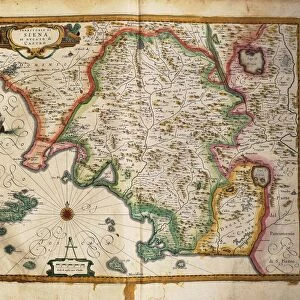
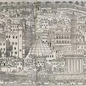
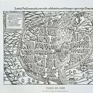
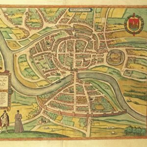
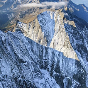
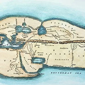
Map of Basel, Switzerland, from Civitates Orbis Terrarum by Georg Braun, 1541-1622 and Franz Hogenberg, 1540-1590, engraving

![]()
Wall Art and Photo Gifts from Universal Images Group (UIG)
Map of Basel, Switzerland, from Civitates Orbis Terrarum by Georg Braun, 1541-1622 and Franz Hogenberg, 1540-1590, engraving
Cartography, Switzerland, 16th century. Map of Basel. From Civitates Orbis Terrarum by Georg Braun (1541-1622) and Franz Hogenberg (1540-1590), Cologne. Engraving
Universal Images Group (UIG) manages distribution for many leading specialist agencies worldwide
Media ID 9505483
© DEA / R. MERLO
16th Century Aerial View Basel Book Bridge City Cityscape Connection Franz Hogenberg Georg Braun Guidance Human Settlement Nautical Vessel Navigational Equipment Number Old Town Page River Road Ship Switzerland Text Transportation Western Script Color Swatch
FEATURES IN THESE COLLECTIONS
> Aerial Photography
> Switzerland
> Architecture
> Country
> Switzerland
> Arts
> Artists
> H
> Franz Hogenberg
> Arts
> Landscape paintings
> Waterfall and river artworks
> River artworks
> Europe
> Switzerland
> Aerial Views
> Europe
> Switzerland
> Basel
> Europe
> Switzerland
> Maps
> Europe
> Switzerland
> Paintings
> Europe
> Switzerland
> Rivers
> Europe
> Switzerland
> Sculptures
> Universal Images Group (UIG)
> Art
> Painting, Sculpture & Prints
> Cartography
EDITORS COMMENTS
This print showcases a remarkable piece of cartography from the 16th century - a Map of Basel, Switzerland. Created by Georg Braun and Franz Hogenberg, two renowned engravers of their time, this exquisite work offers a glimpse into the city's rich history and topography. The map depicts Basel in stunning detail, with its winding roads, majestic bridges, and bustling river filled with ships. The old town is beautifully illustrated, showcasing its architectural marvels that have stood the test of time. Every line and stroke on this engraved image tells a story of human settlement and connection. As you explore this aerial view of Basel through the lens of history, you can almost imagine yourself traveling back in time to experience life in this vibrant city during the 16th century. The carefully crafted text provides guidance for navigation while adding an artistic touch to the map. This horizontal composition captures both the grandeur and intricacy of Basel's landscape. With no people present in the scene, it allows us to focus solely on admiring the artistry behind this masterpiece. Whether you are an avid historian or simply appreciate fine art, this Map of Basel will transport you to another era as you delve into its colorful swatches and meticulously etched details. It serves as a testament to our enduring fascination with maps as tools for exploration and understanding our world's past.
MADE IN THE USA
Safe Shipping with 30 Day Money Back Guarantee
FREE PERSONALISATION*
We are proud to offer a range of customisation features including Personalised Captions, Color Filters and Picture Zoom Tools
SECURE PAYMENTS
We happily accept a wide range of payment options so you can pay for the things you need in the way that is most convenient for you
* Options may vary by product and licensing agreement. Zoomed Pictures can be adjusted in the Cart.